Last Updated on: 10th November 2023, 07:32 pm
Web site: www.geolivre.org.br (not active)
Origin: Brazil
Category: Specialist
Desktop environment: KDE
Architecture: x86
Based on: Kurumin
Wikipedia:
Media: Live
The last version | Released: 5.0 | January 22, 2006
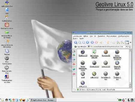
GEOLivre Linux – a Kurumin based live CD Linux distribution geared towards geographical use. Among its specialist software one can find MapServer, GRASS, JUMP, QGIS, Thuban, GPSMan, GPSDrive and other related applications.
Between the applications that it includes, they can stand out:
– UMN MapServer, an API for the development of web-based GIS applications.
– PostgreSQL / PostGIS, spatial database system for vector data analysis.
– Open 3D GIS, GIS 3D solution, for advanced visualization of spatial data.
– GMT, collection of tools for manipulation of 2D and 3D geographic data.
– GRASS, a classic in the open-world GIS world.
– UDIG, multi-format GIS application management system.
– JUMP, Java framework for the development of GIS applications.
– Terraview, easy-to-use geographic data visualization system.
– SPRING, a GIS of Brazilian origin and also totally open.
– QGIS, geographic data viewer with friendly interdace.
– Thuban, visualizer written in Python, very friendly.
– MySQL, database system, well known.
– QCAD, free CAD program with lots of useful resources.
This distro has been developed in Brazil by the OpenGEO company, dedicated to geotechnologies and the development of open source corporate applications.